
What’s Happening with Raleigh’s BRT and Transit Overlay Districts
There seems to be some confusion about a portion of the proposed changes to Raleigh’s Transit Overlay Districts (TOD). (TC-2-23) is coming before the Planning Commission’s Text Change Committee on June 7th. Before getting to that portion of the text, let’s briefly touch on the parts of the text change that are not controversial. Staff initiated TC-2-23 because residents raised concerns about the TOD provision prohibiting construction of single-family and duplex housing. Because TODs are intended to encourage higher density mixed-use development near Raleigh’s proposed bus rapid transit lines (BRT), the current TOD prohibits low density residential structures. Shortly after the original TOD was enacted, some residents raised concerns that the current TOD ordinance prohibited the rebuilding of homes within a TOD.
After considering these concerns, staff determined it was reasonable to remove the prohibition because it was unlikely to substantially undermine the intent of the TOD. Removing the prohibition is unlikely to result in the construction of low-density housing due to prevailing market conditions. It simply makes no economic sense to build or rebuild single-family or duplex housing within a TOD that encourages higher density development. Another noncontroversial component of TC-2-23 imposes caps on the amount of office, retail and similar uses allowed inside apartment and other mixed-use buildings.
However, there are a few members of the community suggesting that another provision of TC-2-23 will significantly impact Neighborhood Conservation Overlay Districts (NCODs) and Historic Overlay Districts (HODs). The specific provision in question addresses what happens when a TOD and an NCOD overlap. To understand what is and isn’t at stake, it’s important to understand the role of TODs, HODs and NCODs.
Preserving Raleigh’s Character or Preserving the Status Quo?
Raleigh’s website calls NCODs and HODs “Character Preservation Overlay Districts.” However, they differ in some important respects. Intended to preserve the historic character of a neighborhood, Raleigh’s HODs preserve the historic character of the older neighborhoods in Raleigh. Those neighborhoods are mostly in a ring around downtown and include Boylan Heights, Prince Hall, Oakwood, and Brooklyn. HODs tend to regulate building design, architectural features, etc. Importantly, while HODs do not set a specific building height, they do require that buildings be “congruous with the height of typical, well-related nearby buildings and structures.”¹ It’s also important to note that HOD’s are regulated by the City’s Historic Development Commission.
NCODs, on the other hand, cover a larger portion of Raleigh’s neighborhoods. NCODs seek to preserve the current character of a neighborhood, but not historic character. A typical NCOD has looser regulations than an HOD, regulating setbacks, lot sizes and building heights without restricting the architecture used in the district. In practice, they tend to preserve the status quo of the area where the NCOD applies.
Moving Beyond the Status Quo with TODs
While HODs and NCODs focus on preserving Raleigh’s present and its past, TODs are forward-looking by setting the conditions for successfully implementing the voter-approved Wake Transit Plan, particularly the Bus Rapid Transit Component.
As Raleigh grows, managing the city’s transportation system will become increasingly important if the City is to be affordable and livable. Like a number of other cities, Raleigh is pursuing a BRT system that aims to provide expedited service along key corridors. The BRT system connects to the rest of Raleigh’s transit system by a network of frequent bus routes. Once built-out, BRT will allow people to quickly and predictably travel along these corridors without the use of a car. For BRT to succeed, it’s vital that Raleigh add significantly more mixed-use development along the BRT routes so that people can live, work, and shop within a short walk of a stop.
Enter TODs. The City is applying these overlay zoning districts to encourage urban mixed-use development. The City hopes that incentives like height and residential density bonuses will encourage denser residential density. Keep in mind that the TODs do not change the underlying zoning districts. So, if a property is zoned for only residential uses, the TOD will not change the actual uses allowed under that district. At the same time, TODs generally prohibit auto-dependent uses like convenience stores, auto repair shops, gas stations, drive-thru restaurants and other uses that generally detract from a neighborhood’s walkability. In short, BRT and TODs work together to take cars off the roads, reduce environmental impact of traffic and sprawl by allowing more people to get around without a car.
Here's where the confusion comes in. Some people in the community are suggesting that TC-2-23 will negatively impact historic districts. In fact, none of the current or proposed overlap any current HODs. Furthermore, while there is overlap with the NCODs, NCODs are not historic preservation districts. Instead, they often tend to limit the ability of neighborhoods to evolve and adapt to changing circumstances. In that way, they tend to restrict what owners can do with their property. Allowing TODs to supersede NCODs in limited circumstances makes sense from a public policy perspective if the goal is to ensure successful implementation of BRT and the Wake Transit Plan.
Let’s look at the current and proposed TODs and potential impacts to NCODs.
Western and Southern BRT Corridors
The City already rezoned TOD districts on BRT routes along Western Blvd, Martin Luther King Jr Blvd. However, the rezonings are limited and do not currently overlap with any HOD or NCODs, as the below maps show. The City will refine these TODs during station area planning for the Western and Southern corridors. Contrary to criticism about a lack of robust resident engagement, the structure of those processes and the appointment of resident leadership committees for both the Southern and Western BRT Routes will be considered by Council on Tuesday, June 7th. Additionally, Council will consider hiring 2 paid Neighborhood Ambassadors for each BRT route to enhance resident engagement as the City refines the planning around future BRT stations.
Western Corridor

Southern Corridor
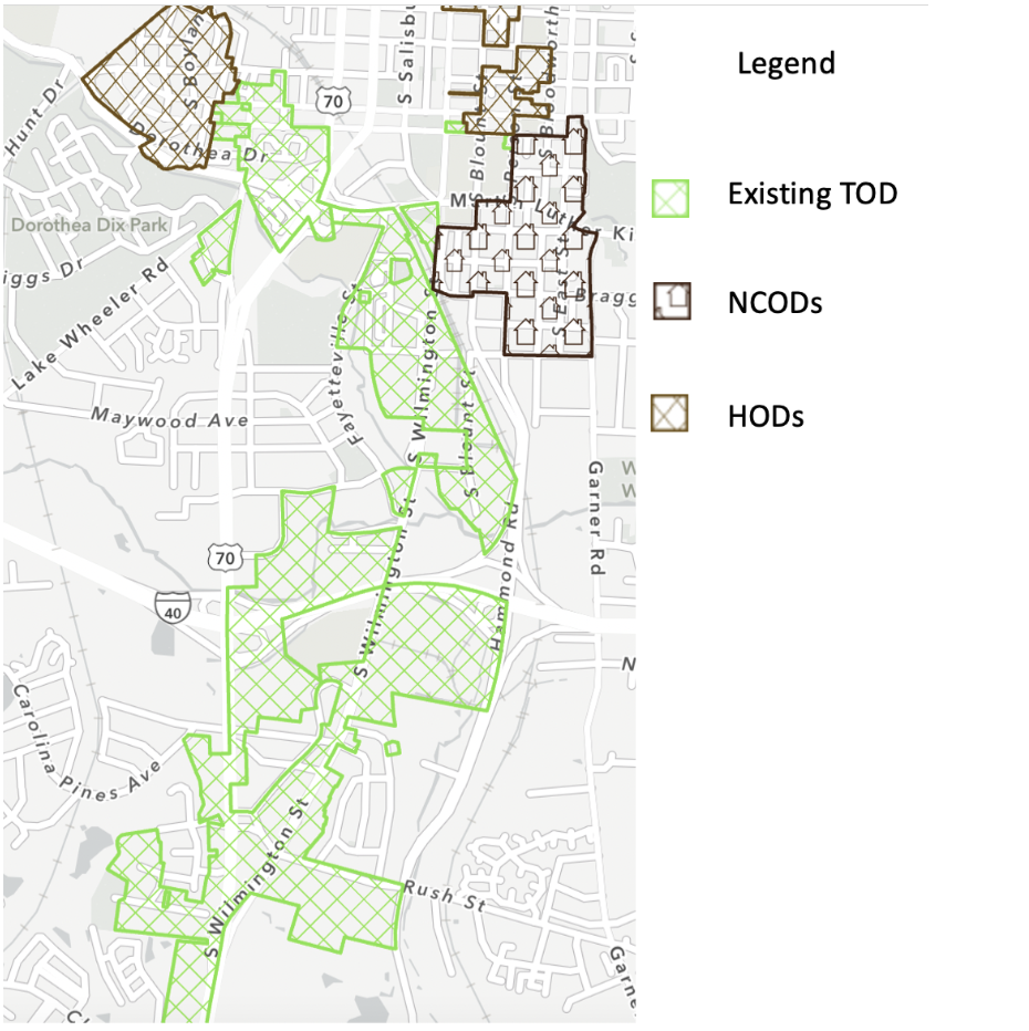
New Bern Avenue BRT Corridor
First and foremost, it’s important to note that the proposed TOD for the New Bern Avenue BRT Corridor has not been approved. It is currently under review by the Planning Commission (Z-92-22) and tentatively scheduled to be considered by Planning Commission’s Committee of the Whole on June 12. The proposed location for the New Bern TOD was developed after completing a detailed community engagement process around each proposed BRT station locations. Additionally, the City completed an 18-month study of the New Bern Avenue corridor which also included deep community engagement. Those planning efforts and related community input is being incorporated formally into the City’s plans through (CP-7-22). That amendment to the City’s Comprehensive Plan is being used by the City to refine the location of the proposed TOD. CP-7-22 is scheduled for consideration by the Planning Commission at its June 13 meeting. Even after those extensive engagement efforts, the City will gather additional input from residents about where the New Bern Avenue TOD will apply during the formal review of Z-92-22 by the Planning Commission and City Council.
With that in mind, the proposed New Bern Avenue TOD does overlap with two NCODs:
The New Bern-Edenton NCOD, along New Bern Ave from Bloodworth St to State St
The King Charles (South) NCOD, from Bertie Dr to Peartree Ln and Donald Ross Dr
The proposed alignment covers about half of the New Bern-Edenton NCOD.

As the map below demonstrates, the overlap encompasses a relatively small portion of the King Charles (South) NCOD. The overlap primarily encompasses parcels lying along New Bern Ave, which is a busy thoroughfare road as opposed to a quiet neighborhood street.

Public Input Opportunity
Regardless of your view, please consider letting the City know how you feel. You can attend the Planning Commission’s Text Change Committee meeting scheduled for Jun 7th or the Committee of the Whole meeting on June 12. Also, be on the lookout for City Council meetings when TC-2-23 is scheduled for consideration. Agendas are posted here.
If you are unable to attend the meetings, you can send comments on the proposed TOD or TC-2-23 to Planning Commission directly using this email: email-Planning.Commission@raleighnc.gov.
Similarly, you can send comments to City Council using this email: citycouncilmembers@raleighnc.gov.
Displacement and Gentrification Concerns
Like most fast-growing cities, residents are concerned about displacement and gentrification around TODs and BRT routes. Notably, the City is acquiring property along New Bern Avenue that will be used to help begin addressing these concerns by providing small-scale retail and affordable housing opportunities. Additionally, the City recently submitted a $20,000,000 bid to the State for the acquisition of the abandoned DMV property located on New Bern Avenue. If accepted, the City will also use that property to address issues of displacement and affordable housing. Finally, the City established the Public Project Community Support Fund which is intended to preserve neighborhood stability and enable businesses to help with neighborhood preservation.
Conclusion
A strong public transit system is vitally important for Raleigh’s evolution. If you want people who work in Raleigh to also be able to choose to live in Raleigh, implementing a robust transit system is critical. But for that to happen, BRT corridors must be supported by dense, walkable development that TODs are intended to foster.
Editor’s Note (August 30, 2023): At last night's Planning Commission Committee of the Whole Meeting, the commissioners noted that overlap between the TOD and NCOD is likely to be a source of significant public confusion. The commissioners asked staff to draft new policy language that would address this overlap, including the potential removal of the NCOD designation altogether from parcels where the TOD is imposed. We will continue to monitor the situation as the Commission and eventually the Council evaluate how to handle this overlap.
Raleigh Unified Development Ordinance, Article 5.4